Name
the United Nations Vector Tile Toolkit (UNVT)
Purpose
- Enable everyone to produce, style, host, and optimize Vector Tiles (VT).
- Promote sharing of ideas and techniques on VT.
Background
VT technology is a latest web map technology also used by digital platformers.
VT technology is promising especially in environments with limited information and communications environment for VT are smaller than traditional image tiles and also machine-readable.
Geospatial Information Authority of Japan (GSI) has been contributing to the UN Open GIS Initiative by sharing its Web Map expertise with UN Geospatial including UN Global Service Centre since 2017.
Overview
1. Produce
Convert Source Data into GeoJSON Text Sequence (GeoJSONS) with injecting Vector Tile Design Configuration.
Feed the sequence into Tippecanoe to produce MBTiles of VT.
In the case of smaller Source Data, extract MBTiles into a filesystem with tile-join.
In the case of larger Source Data, production will be done in a modular manner where Source Data are split into modules of several gigabytes.
Tile Designer’s product
VT Design Configuration. The configuration is usually a JavaScript or Ruby script which takes a GeoJSONS from standard input, filters features with adding GeoJSON extention for Tippecanoe, and stream them to standard output as GeoJSONS.
2. Style
Generate a style.json which conform to
Style Specifications
and in harmony with a VT Design Configuration.
Human-Optimized Config Object Notation (HOCON)
was introduced to organize the style configuration layer-wise
because in most cases a style.json is large and complex.
Style Designer’s product
VT Style Configuration. A set of HOCON files (*.conf) in most cases.
3. Host
Host the product on the Web.
In the case of smaller Source Data, first we host the product locally using budo, and then use GitHub Pages to publish it.
4. Optimize
Analyze zoom-wise size distribution of VT using vt-optimizer. Continuously improve VT Design Configurations.
Supporting Features
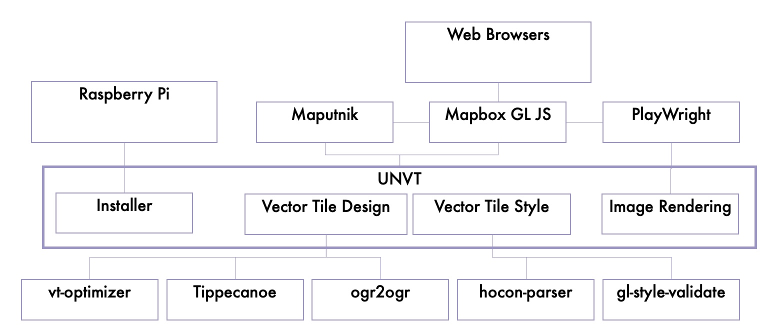
equinox: UNVT installer for Raspberry Pi OS
UNVT so faithful to design principles of Unix and the Web that UNVT capacity building was difficult on Windows.
We usually use Raspberry Pi for UNVT capacity building. We have UNVT installer named equinox for Raspberry Pi OS.
We sometimes use Docker, too.
plow: Server-side image tile rendering PoC
VT can even benefit GIS without VT support by its higher update frequency or its flexibility in style. Server-side on-demand image tile rendering is a way to support legacy GIS without VT support.
plow is a proof-of-concept (PoC) of server-side on-demand image tile rendering using PlayWright.
GSI is also working on server-side on-demand image tile rendering.
System Context Diagram
Related Projects
Adopt Geodata (optgeo) project
Adopt Geodata (optgeo) project is a project in tandem with UNVT.
The purpose of the project is to demonstrate the value of VT, and to continuously improve UNVT, by creating VT from open geospatial data which are not yet in VT.